Hike 38: Tuscon botanical garden

This trip had a very special meaning for Brook. One of the reasons we went to Tuscon was to visit her old mentor, Harlow!

Harlow helped Brook through her time as a new nurse, and was instrumental in her confidence as a health care professional. Harlow is a great friend, and spends some of his time in retirement volunteering at the botanical garden.

Cool red pointy cactus

this was an interesting hike, because not only did we get to see a bunch of cool desert plants and a butterfly house, but there was a virtual art exhibit as well, where different art pieces could be viewed the the lens of our phone cameras.

Butterfly in the butterfly house

I will always be grateful to Harlow for what he did for my wife early in her career.

Hike 36: Sentinel Peak Park

For the next three hikes, we went to Tuscon Arizona. This was a really cool time for me, as I remember that Tuscon was where Dad used to work quite a bit. It felt nice to visit a place that Dad spent so much time at.

This first hike was at Sentinel Peak, which is a mountain in the center of downtown. We could almost drive all the way to the top of the mountain.

Downtown Tuscon from the top of the mountain

This was a short hike, but a great one. In the tradition of most cities, a big letter was placed on the hillside; in this case the letter “A”.

Me standing next to the giant “A”

It felt good to get out of the rain for a bit and see a place that Dad enjoyed being at.

Hike 35: Silver Peak

Silver peak was another hike off the PCT…so now I can say I did the PCT twice!

Some fall foliage still on the PCT

The Silver peak trail itself was incredibly steep…mostly just rocks that had to be climbed over.

PCT trail marker

I almost made it to the top, but the trail turned into a scramble along the side of a cliff, so I turned back.

The “trail” is an outcropping from a cliff. Guess I need to work on my climbing!

As you can see, not much view this hike, but there was at least a heck of a workout!

Another amazing Pacific Northwest view!

Hike 34: Monastery at San Juan Bautista

This is a special hike for me. This hike was at the property of San Juan Bautista Monastery outside of San Jose California. I was at this monastery at an Alcoholics Anonymous retreat with a wonderful group of men.

One of the “stations of the cross” at the monastery

View from the top of the bluff

Me and three other guys went up this trail called the Brothers’ Way. There are no pictures or names of these awesome folks that I hiked with, because our anonymity is our own, and I will not blow my friend’s anonymity. I will not go much more into this, as humility is the cornerstone of the Program, and I do not wish to compromise my own program by bragging about it. I will only say that it saved my life, and my soul, and if you think you might have a problem, I am happy to take you to a meeting; it is a program that must be shared.

Hike 33: South Tiger Mountain

In my mission to do all the tiger mountain summits, South Tiger got me 3/4 of the way there! South Tiger mostly done via an old logging road. It starts out with a nice forest trail up to an old logging road.

Trail leading up to the logging road at south tiger

After going up several logging road switchbacks, the trail cuts off, and traverses areas that have been logged. The trail is pretty overgrown, and in the fall there are spiderwebs everywhere!

Standing at a cliffside where the power lines go down.

On the way back I realized that I could take the logging road most of the way back down…to avoid spiders, I did exactly this.

At the top, there is a little collection of stumps at the lookout point. Today there was a beautiful view of Rainier.

Makeshift seating area at the summit

Mt. Rainier from South Tiger summit

Hike 32: Tommy Thompson trail

Brook and I did this trail when we were in Anacortes. Anacortes is a little town in the Pacific Northwest that happens to be the town that Brook grew up in!

Brook and I on the bridge

This trail goes through the town of Anacortes, and over this giant bridge to the oil refinery.

The fallout from the storm the night before

One of the cool things about this trail, is that seagulls use the bridge to break shells in order to get to the goodies inside. In front and behind us, we heard and saw clams being dropped from altitude. Though slightly disconcerting, it was pretty cool to see.

The remnants of seagull dinners

Also on our walk, we saw a group of otters swimming offshore!

Otters swimming offshore

This was a very cool hike; I always feel at home by the shore, and the salt water spray.

Random stone animal


Hike 31: Lizard Bat trail in Sedro Wooley

Only in Washington can you find this many weird place names strung together in a sentence. I admit, we did the Lizard Bat trail solely because of the name.

Mushrooms growing inside the tree

I cannot say that this was the best hike I have ever been on…the rain was pelting sideways, and making me generally miserable, much to Brook’s amusement. Usually I am the one dragging her up trails, but this time, she got the last laugh.

I am trying to smile…

I discovered something about myself: I hate getting wet!

Hiking in the storm

Eventually, the wind picked up, and ushered in the first big windstorm of the season, and we had to turn back, as branches were coming down, and crashing around us.

Hike 30: Nachez Peak loop with the Lyons

We did this on the second part of our day at Mt. Rainier. This time, we met up with our friends and neighbors across the street, Dave, Drea, and Nate! The trail we did here, Nachez Peak loop, is one that Dave spent a lot of time at in his childhood. Growing up in Yakima, it was actually a pretty quick trip to this area.

One more dad on the trail! Dave and his son, Nate.

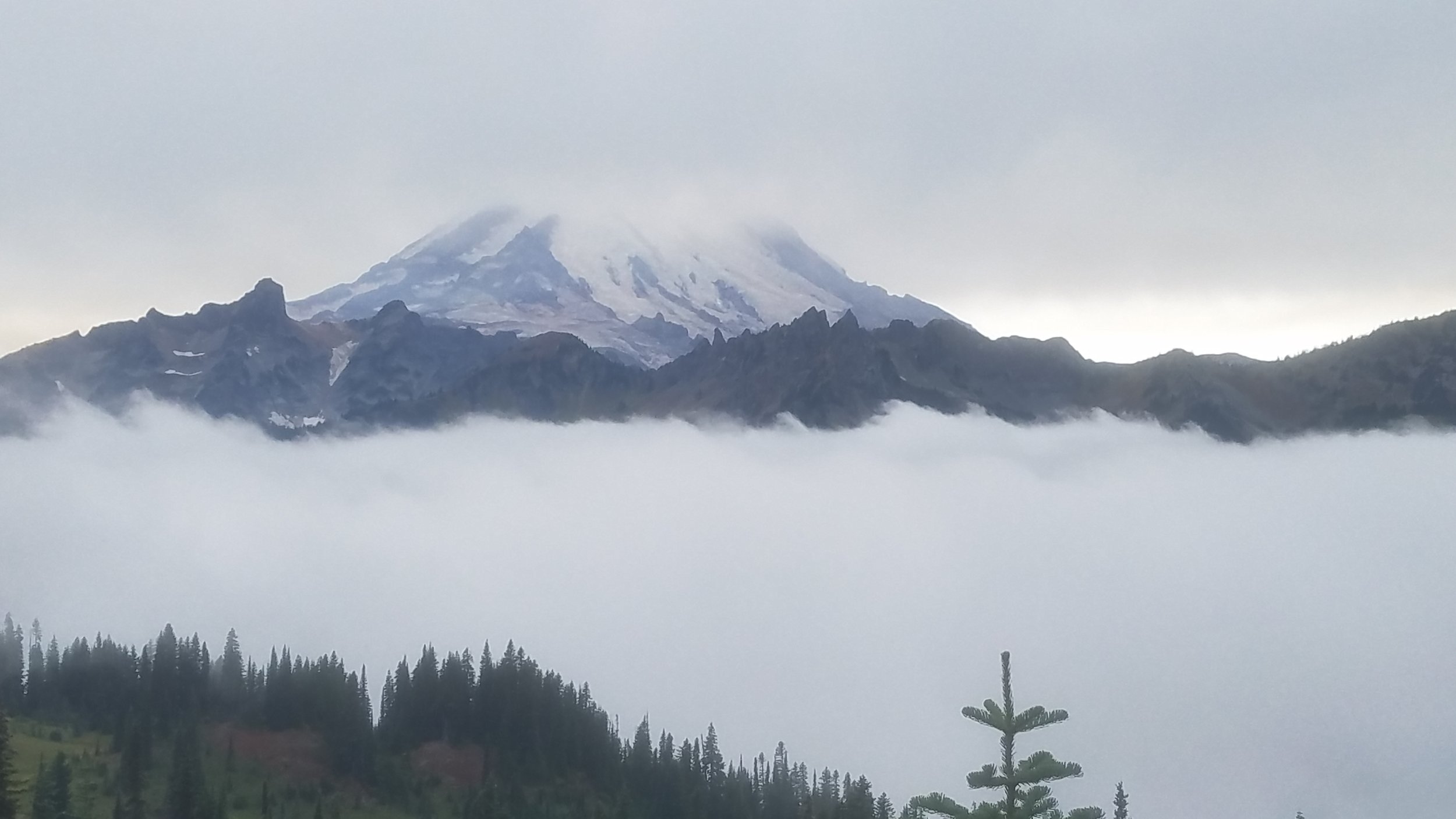
The weather today was really cool; the clouds and fog put Mt. Rainier into contrast, and made it seem as if it were a floating mountain. The views at the time were incredible.

Mt. Rainier

Soon, the views became less incredible as the front came in and fogged everything!

Same view, zero visibility

The foliage and scenery were still beautiful though, and we even got to hike a bit of the famous PCT!

Now we can say we hiked the PCT!

Thank you to our great friends and neighbors for coming up to the mountain with us!

Serious face

Silly face!

Hike 29: Sheep Lake at Mt. Rainier

I have to say, this is one of the most beautiful hikes I have ever taken. The area around Mt. Rainier in the fall is incredible.

Patrick on the trail

Fall foliage

We actually did two hikes this day: this first one was to Sheep Lake. The trail starts by following the road through some of the most breathtakingly red foliage you could find. I don’t think I’ve ever seen anything quite like it.

Me and Brook’s boot-prints on the trail

Then the trail goes through some forest that looks like something from Lord of the Rings, and eventually yields a mirror-clear mountain lake. I freaking love the mountains!

Sheep Lake

This is one of the most serene places I have seen, especially first thing in the morning.

Brookie loving the lake

Hike 28: Coal Creek Park

This hike is literally in our backyard! A couple blocks away up Coal Creek Parkway is a beautiful greenbelt that provides a pleasant walk through the forest, and down the creek itself.

Coal Creek

The interesting thing about this hike, is there is actually some history around this trail.

Back in the 1800s, and early 1900s, our neighborhood was actually the site of a coal mining operation, hence the name. Trains carrying coal used to travel along a track that existed in this park.

Old photo on an interpretive sign

Several old relics dot this trail including a very old U.S. Postal vehicle!

An old mail truck: possibly 1930s?

I love living here, and I am so thankful such natural beauty and history exist so close to where I live! I will never take this for granted.

Brookie on a bridge!


Hike 27: Margaret's Way to Debbie's View

For this hike, I took a trail that was close to home: Margaret’s way off of highway 900. When I first attempted this hike about 3 years ago, I hated it. Since then, I have realized that the only reason I hated this hike, is that I did not have hiking boots, poles, adequate water, and we started late, so it was hot and buggy.

Campsites at the switchbacks

After fixing all these variables (and getting a bit more in shape), Margaret’s way is actually a very pleasant hike up Squak Mountain. It starts out at this random campground, where the campsites are actually on the switchbacks of the trail. I have to admit, I have not seen anything like this before.

New trail under construction!

After the campground, the slope gets steeper, and we go up a gravel road where the foliage changes back and forth from old growth to deciduous, likely due to past logging.

Selfie at one of my favorite spots: Debbie’s view. Normally Rainier is out, but it was hazy this day.

At the top is one of my favorite places to go for serenity: Debbie’s view. Morning is best, before it gets too crowded. I love this hike; it’s not too technical, it has a beautiful view, and the trail is very well maintained.

2021 Hike 26: The Brethren camping adventure (part 2)

The next hike we did was about a mile and a half walking the trails on Sam’s property. On this hike was Sam, Steve, Justin, and myself. Unfortunately, Chad had to leave, as he was made aware of a friend’s father’s funeral, so his trip was cut short so that he could support his friend.

Steve, Sam, and Justin on the trail

On this hike, Sam took us around to the possible build sites for various structures he is planning. One of which is an armory, complete with a forge and smelter. I’m not sure if his wife knows about this yet, but I am FULLY onboard.

Justin and Sam

This was the last thing we did on this adventure, and I am hoping we make this an annual event. Next time, I am aiming for all six of us!

Things we learned on this half of the adventure:

  • It is difficult for 2-wheel drive vehicles to get up a 30 degree slope with wet grass.

  • If you are planning on doing a 2 mile swim after going on a 5 mile jog, you may want to drink some electrolytes and eat a bit of protein. (Again, looking at you Justin). Thankfully Sam had a paddleboard that acted as a convenient Justin-tow in a pinch.

  • DO NOT put giant, top-heavy wood into a 1.5-foot-wide burn barrel. I’m not saying we tried to burn the forest down, but…well…there were some tense moments.

2021 Hike 25: The Brethren camping adventure

A little context for this one. Some of you may remember from 2020 before COVID on the first attempt at this challenge, we hiked with the families of Sam Affolter, and Justin Wahlborg. These are a couple of the people I’ve known since I was a High School Freshman. In the mid-nineties, six of us came together and formed a group we called “The Brethren.” (No, it’s not a cult, it is a reference to the movie ‘Highlander.’)

Due to our…unique…senses of humor, love of 80s cinema, and the fact that we didn’t really fit into any of the other social groups at the time, we quickly developed lasting bonds of friendship that we still have to this day.

Anyway, back when you could buy property in the Pacific Northwest without having to sell internal organs to afford it, Sam purchased a prime spot of waterfront across the Tacoma Narrows bridge on the peninsula, which was the site of a reunion of The Brethren! In this picture, you see five of the original six (clockwise from left): myself, Chad Lind, Justin Wahlborg, Sam Affolter, and Steve Johnson. Missing from this photo is Bear McCreary, who is currently busy taking over the filmscoring industry in Hollywood. Next time, Bear!

The Brethren: Patrick, Chad, Justin, Sam, Steve. Not pictured: Bear

The hike we did today was down to the beach, and on the shore for about a couple miles. The descent from the bluff to the beach was actually a bit technical, as Sam and his brother learned a valuable lesson while developing this property: if you build a staircase into a cliffside made out of clay, it does not stay put. I do not even have a picture of this staircase, as it was so hazardous, that I needed both hands free to navigate it! Picture an M.C. Escher painting meets the Battle of Britain, and this was what we traversed.

Steve, looking very much like a warrior monk with his gigantic walking stick

Chad and I taking a break in some random chairs that were sitting on the beach

Once down to the beach, we looked for more oysters for Sams oyster farm. Unfortunately, due to the 110 degree heat this summer, most of his oysters died off, so they needed replenishing.

Sam, rebuilding his oyster cache

What we learned so far in this trip:

  • If you want to camp, you should probably bring a tent (looking at you, Justin). Thankfully there is a cabin on the property.

  • Staircases built into clay will disintegrate in a very dramatic fashion.

  • Literally everything can (and should) be cooked with a wood fire.

2021 Hike 24: Humpback Mountain

We are back in the Puget Sound after an amazing trip to Glacier. I thought Humpback Mountain would be a quick hike to do, as it was only four miles out and back. I was wrong. I only did half of this hike for a number of reasons.

Pretty flower I saw on the trail

Pretty flower I saw on the trail

Interesting berries that look decidedly inedible

Interesting berries that look decidedly inedible

This hike is only 4 miles out and back, but has an elevation gain of about 2900 feet. The trail is mostly a 45 degree angle, and the beginning stretch is made of soft sand and aggregate (probably due to a slide)

This is the trailhead.  What you don’t see is that it gets even steeper and more treacherous just past the left side of the frame.

This is the trailhead. What you don’t see is that it gets even steeper and more treacherous just past the left side of the frame.

After clawing and scraping my way up and through loose and fallen trees, the trail ascends steeper and steeper, until it’s little more than a deer track.

Trail looks pretty good…for now

Trail looks pretty good…for now

This is the trail from a level shot…my head is not bent while taking this picture.

This is the trail from a level shot…my head is not bent while taking this picture.

Normally I would be willing to give it a go, but a few factors made me turn back:

  1. I was hiking alone

  2. There was nobody else on the trail

  3. I was losing battery life and reception on my phone

  4. I began to lose the trail

Due to these things I decided that it would be stupid to continue…I am all about an adventure, but my first priority is making it out safely, and this felt like a recipe for disaster. In addition to the factors above, I had this unexplainable feeling in my gut that said that this just felt “wrong.” Heeding my instincts bolstered by reasons above, I made the decision to call it. I will hike another day.

2021 Hike 23: Iceberg Lake - Glacier

Simply put, this was one of the most memorable hikes I have ever done, for a variety of reasons. Quite possibly one of the most event-filled and unique hikes of my lifetime. Starting off, we leave from the same trailhead that took us to Ptarmigan Falls earlier.

This hike gains about 1700 in elevation overall, but most of the gain is in the first 1.5 miles. As we hauled ourselves up the mountain with our trusty bear spray, water filters, and trail mix, we were greeted by expanses of mountain forest, as we climbed out of the basin.

Getting our first elevation out of the forest

Getting our first elevation out of the forest

It was a good thing that we started early…our good friends, the bugs, came out to play. More on that later. The climb turned out to be quite exposed, and hot, so we made sure to take breaks along the way, and enjoy the view.

That same basin from a higher elevation

That same basin from a higher elevation

During the last stretch before the descent to the lake I crested a ridge, and saw a lady in the distance shouting “Stop the trail! Stop the trail!" Then, the biggest animal I have ever seen in my life walked across, about 50 feet from me. I have never seen a bull moose, so I have no frame of reference; it was bigger than I ever thought it would be. Definitely a first in my life. On the other side of the trail, the moose settled onto a snow patch, and began eating snow to cool down. Smart moose.

Just munching snow, being a moose

Just munching snow, being a moose

After taking those pictures at a safe distance, we proceeded to leave, as calmly but efficiently as possible. Thank God it was a chill moose.

Me with my best “This is awesome, but let’s get the hell outta here” expression

Me with my best “This is awesome, but let’s get the hell outta here” expression

As we came down into the lake, it was like nothing we ever saw before. I was expecting that the name might have been a figure of speech, or maybe the lake had a couple broken pieces of melt floating around…nope, these were legit icebergs floating around in this lake. I don’t know what kind of geology or meteorology causes this…that’s for smarter people than me to figure out; I just sat there stunned.

Iceberg lake

Iceberg lake

Patrick and Brook at Iceberg Lake

Patrick and Brook at Iceberg Lake

After about an hour at the lake, the bugs got a bit more than we could bear, so we left. The hike back was a little easier slope-wise, since we were going downhill, but the heat and bugs began to take their toll. Bugs were in our eyes, our noses, our mouths, and after a fly flew directly into my ear, I was over this trail. I had to pick the bug out with my finger which was an experience in itself.

As we were getting closer to the trailhead, we turned a corner, and we saw a big crowd of people with giant cameras looking off the side of the trail. I said “Hey Brookie, there’s your bear.” I was correct; a grizzly bear was hanging out in the meadow just chilling, getting it’s picture taken. Unfortunately we didn’t get any pictures of it, because it did what bears do, and ambled away from the large group of people. Much like myself, they are not social creatures. Today on the trail, Brook conquered her fear of bears!

What an amazing day. I will always remember this hike.

2021 Hike 22: Ptarmigan Falls - Glacier

Our next hike in Glacier took us to Ptarmigan Falls. This hike is in the Many Glacier area of East Glacier Park. In my opinion, the Many Glacier area, and some of the more secluded areas in East Glacier, are much better to visit than the famous Going to the Sun Road. You don’t need a permit to come here, the hikes are better, and there are fewer people.

Photo of a deer butt

Photo of a deer butt

This hike starts off at a campground next to the Glacier Hotel, and has a pretty steep elevation gain right off the bat. The gain to the falls is about 700 feet, but it starts at 5000 feet above sea level, and most of the gain is in the first half mile.

going up into the mountains!

going up into the mountains!

Getting to the falls was beautiful, minus a couple panic attacks regarding the possibility of seeing Grizzly bears. One of the things I assured Brook though, is that you can spot a Bear from a distance, by finding the huge crowd of people with giant cameras trying to take a picture of it. Given that we didn’t see this, we were good. We did, however, come prepared with bear spray just in case.

blue and red rocks at in the pools of the falls

blue and red rocks at in the pools of the falls

When we got to the falls, they were beautiful, and the stones that you see below were quite unique, but we hightailed it out of there, because the bugs were so incredible, that not even repeated applications of repellent could keep them away. It was truly reminiscent of Dad and my trip to Copper Lake…I have not seen so many bugs in one place since then.


2021 Hike 21: Twin Falls at 2 Medicine Lake - Glacier

This was our first hike in Glacier National Park! Neither Brook nor I have been to Glacier, and this was Brook’s first road trip, so this was a milestone! For this hike, we actually took a boat tour from the launch to the other side of the lake, and walked the trail from there.

On the boat, going to the trailhead

On the boat, going to the trailhead

Once on the other side of the lake, the trail was a fairly flat, with a slight incline about a mile and a half in, until we reached the falls.

20210709_162856.jpg
At the base of the falls

At the base of the falls

One thing we were not prepared for, was the amount of bugs that decided to appear and feast on our blood, sweat, and sanity. Thankfully, the wind was up though, so they were kept at bay for a bit, and we got a chance to wade out a bit into 2 medicine.

Posing pensively on the lake shore

Posing pensively on the lake shore

The interesting thing about this lake, is it’s actually about 4000 feet above sea level. This means that I would actually be looking down about 1000 feet to the top of Tiger Mountain that I did earlier this year. Weird!

2021 Hike 20: Gene Coulon Park

It was Father’s Day when this hike was done, so it was a bit of a bittersweet occasion…but I figured getting outside was better than moping around the house, so we did a couple miles up the Gene Coulon trail that borders the southeast portion of Lake Washington in Renton. This trail actually picks up a couple blocks after the Cedar River trail ends at Boeing, and continues up the lake shore.

I again feel super lucky to live in such a beautiful area, as this is a park that is only a couple miles from where we live. This park was named for Gene Coulon, the director of the Renton Parks Department from 1949 until 1977. We are very lucky to have this, as it’s one of the few areas of Lake Washington that has not been turned into private or commercial waterfront real estate.

Even in the city, wildlife still thrives…several turtles routinely make their way to the shore, and are well known to locals.

Turtles in the lake

Turtles in the lake

In this park, there is a piece of art in the form of statues in motion. It is tradition for people to dress these statues up for holidays or other occasions. Here, you can see that someone used a Seahawks shirt, put a stroller there for Father’s Day. I found it a bit humorous though, that nobody is actually holding the stroller.

20210618_120313.jpg
Brook doing “Abbey Road”…though she doesn’t actually know what that is lol

Brook doing “Abbey Road”…though she doesn’t actually know what that is lol

2021 Hike 19: Rex Derr Trail - Winthrop

This last hike in Winthrop was a shorter one; after the crazy steep one the day before, we opted for something a little bit more scenic and flat on our last full day in Winthrop. We found this trail that was right outside the city limits called Rex Derr.

Hey, we finally figured out how to take pictures that aren’t backwards!

Hey, we finally figured out how to take pictures that aren’t backwards!

This trail was named after retired State Park agency director Rex Derr, who loved to come to the Methow valley.

I am so glad we did this trail; one of Brook’s bucket list items is to see fields of wildflowers in bloom, and this area did not disappoint. All sorts of blossoms dotted the fields around Pearrygin Lake, and the late spring clouds and greenery gave it a lush, pastoral feel.

Brookie with flowers

Brookie with flowers

Lots of yellow!

Lots of yellow!

This was a short trail, and we were quite tired, so this blog is somewhat short. In conclusion…here is a picture of a random mammal we saw on the way: